
TL;DR
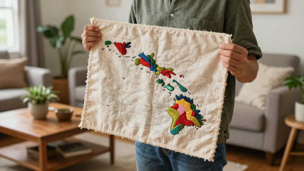
An artist has created two handmade maps of Hawaii: one depicting the entire archipelago including tiny atolls and rocks, and another focusing on the eight main islands. This effort addresses the lack of detailed maps of minor islands online.
An artist has created two detailed handmade maps of Hawaii, including the entire 1,500-mile archipelago and the eight main islands, to address the lack of detailed online representations of the minor islands and atolls.
The first map depicts the full Hawaiian Islands chain from Hawaiʻi Island to Kure Atoll, covering not only the major islands but also tiny atolls, shoals, rocks, and remote fragments scattered across the Northwestern Hawaiian Islands. The creator used Adobe Fresco alongside traditional watercolor and Copic pens to produce this comprehensive visual.
The second map focuses specifically on the eight main Hawaiian Islands—Hawaiʻi Island, Maui, Kahoʻolawe, Lānaʻi, Molokaʻi, Oʻahu, Kauaʻi, and Niʻihau—and was also created with a combination of digital and physical media. It offers more detailed geographic depictions of these primary islands.
Why It Matters
This effort is significant because existing online maps rarely depict the minor islands, atolls, and rocks that make up the full extent of Hawaii’s archipelago. The detailed maps provide a more complete geographic understanding of the region, which can be valuable for navigation, education, and cultural appreciation.

Hawaii Map (National Geographic Adventure Map, 3111)
As an affiliate, we earn on qualifying purchases.
As an affiliate, we earn on qualifying purchases.
Background
Hawaii’s islands stretch over 1,500 miles, but most online maps focus primarily on the eight main islands, leaving the smaller atolls and rocks poorly represented. The creator’s work aims to fill this gap, emphasizing the importance of visualizing the entire archipelago, including its lesser-known fragments. Such detailed mapping has been lacking despite the region’s ecological and navigational significance.
“I wanted to create a map that changed that — one that included the tiny atolls, shoals, rocks, and remote fragments scattered across the Northwestern Hawaiian Islands.”
— creator of the maps
“My depiction of the tiny land geography is actually the depths around them, to give a sense of the scale and the surrounding environment.”
— map creator
HesenDot Natural OAK Wood Framed Hawaiian Archipelago Wall Art,12x16in Kauai Quality Canvas Wall Print,Classic Urban Landmark Wall Decor for Living Room,Bedroom,Office Gallery Set of 1
Stunning Kauai Scenery: This wall art captures the lush, tropical beauty of Kauai, known as the "Garden Isle"…
As an affiliate, we earn on qualifying purchases.
As an affiliate, we earn on qualifying purchases.
What Remains Unclear
It is not yet clear whether the maps will be publicly available for download or use, or if they will be used in educational or navigational contexts. Details about distribution or potential updates remain unconfirmed.
Hawaii Map (National Geographic Adventure Map, 3111)
As an affiliate, we earn on qualifying purchases.
As an affiliate, we earn on qualifying purchases.
What’s Next
The creator may release the maps publicly or share them with relevant communities. Further details on accessibility, potential exhibitions, or digital versions are expected in the coming weeks.

Oahu Map of Oahu Poster Print, Hawaii Island Maps, Handmade Blue Hawaiian Islands 3D Topographic Wall Art Prints by Maps As Art (8" x 10", Portrait (Vertical), Marine)
PRINT ONLY (Frame/Mat Not Included).
As an affiliate, we earn on qualifying purchases.
As an affiliate, we earn on qualifying purchases.
Key Questions
Are these maps available for download or use?
It is not yet confirmed whether the maps will be publicly available or if they will be shared through specific channels.
What inspired the creator to make these maps?
The creator aimed to fill a gap in online cartography by including all minor islands, atolls, and rocks that make up the Hawaiian archipelago.
How accurate are these handmade maps?
The maps were created with a combination of digital tools and traditional media, aiming for geographic accuracy, but their primary purpose is artistic and educational rather than navigational.
Will there be digital versions or prints of the maps?
Details about future availability, including digital or print versions, have not yet been announced.
Source: Hacker News